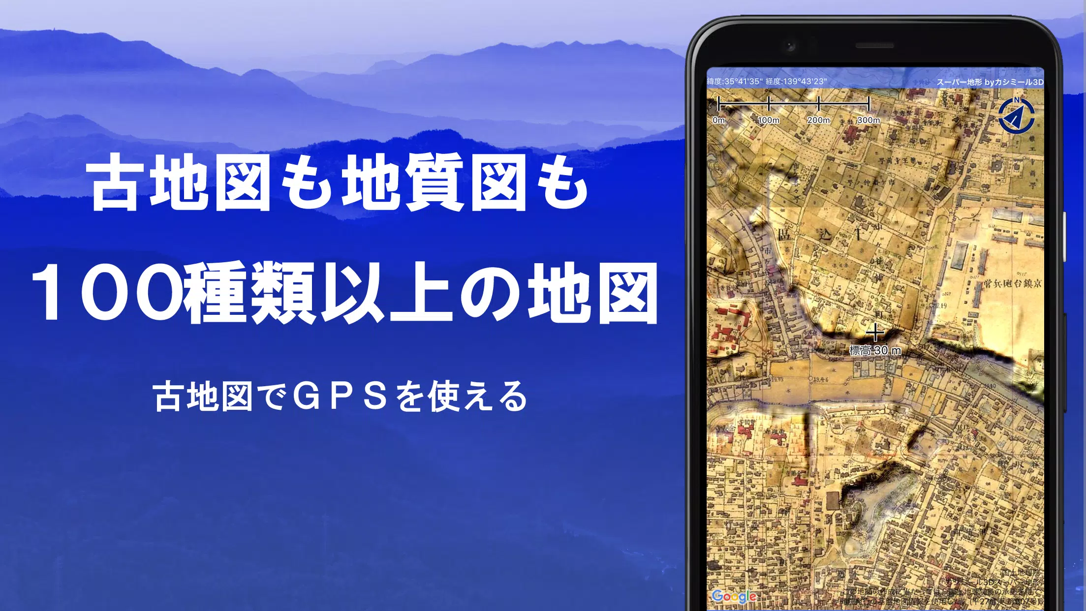
Over 100 types of maps are available for use, including the renowned Geographical Survey Institute map. This map maximizes the height difference from mountain climbing to exploring urban areas, making it ideal for detailed geographical analysis. The product has received the prestigious 2018 Japan Cartographic Society Award for Best Work.
- Utilize advanced "super terrain data" with unique technology to enhance terrain representation.
- Access maps from the Geospatial Information Authority of Japan, including topographic maps, geological maps, old maps, historical maps, and prewar topographic maps (Ordnance Survey Department).
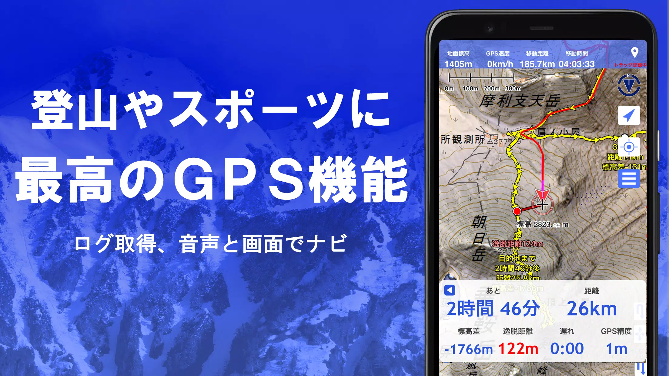
- Record tracks using GPS functionality. GPX log input/output and editing features are also supported.
- Functions designed for urban exploration, mountaineering, and outdoor activities, such as GPS navigation (with audio guidance) and data recording/editing capabilities.
- Visibility determination tool for creating cross-sectional diagrams, observation, radio communication, etc., with buildings displayed.
- Equipped with a 360° panoramic view function, allowing mountain identification and displaying the sun, moon, and GPS points.
- Offline-friendly GPS function, bulk map downloads, and map cache for seamless use in areas without network coverage during climbs or outdoor activities.
- Associate photos with specific points on the map.
- Display contour lines generated from elevation data.
- Show MGRS grid (UTM grid).
- Read, display, and edit GIS data from GeoJSON files.
- Draw various shapes on the map.
- Support for international use.
- Print maps and generate PDF outputs.
- Dark theme support.
A rich variety of maps are available, including more than 100 types of combinations. Our proprietary super topographic data, maps from the Geospatial Information Authority of Japan, hazard maps, and more are included.
*Regarding aerial photographs (grouped by age), some locations may lack coverage depending on the age group. "Latest" and "around 1974" offer broader coverage areas.
*Super terrain data maps can be used for free for five days after installing the app.
Create cross-sections effortlessly through any point on the map. Familiar visibility judgment functions akin to those in Kashmir 3D are integrated, enabling calculations that consider the curvature of the Earth and atmospheric differences.
This tool is invaluable for route planning during climbs, assessing wireless visibility, and comprehending terrain. Where PLATEAU building data is accessible, cross-sectional views inclusive of buildings can be constructed.
Leverage the elevation palette function to modify the map background color in 1cm increments, tailoring it to your preference.
Observe a panoramic view from any point on the map, identifying mountains and their names. Link this with your smartphone’s compass for a 360-degree panorama, aiding in mountain identification. Display the sun, moon, and GPS points, ideal for exploring Diamond Fuji and Pearl Fuji. Panoramic views of mountains abroad are also feasible.
Retrieve location data via your smartphone’s GPS and document tracks. Employ high-precision positioning suitable for rigorous mountain climbing and outdoor activities. Tracks can be visualized graphically, incorporating parameters like elevation change, speed, time, and duration. Point alarms notify users vocally and audibly when nearing designated points. Photos tied to points can be showcased. Share the map center position with NaviCon.
Replay entire track records simultaneously. Align photo timestamps with stored images, displaying icons at corresponding locations and revealing details upon tapping.
Navigate along preset tracks using the Track Navi feature and your smartphone’s GPS. Deviations trigger audible alerts. This ensures no disorientation during climbs. Additionally, route navigation tailored for urban exploration and point navigation targeting single points are available.
Handle GPS-related point, route, and track data efficiently. Organize by folders in a readable tree format. Directly draw tracks on the map. Import/export in GPX format from mountain climbing sites.
Utilize maps even in areas lacking signals, such as during mountain climbing. Bulk download guarantees downloading all scale maps for a specified area. Monitor downloads visually to avoid missing maps on-site. Cache functionality is also available.
Recall previously viewed locations. Easily return to earlier spots.
Import and employ custom maps crafted using Kashmir 3D’s map cutter. Display and use personal maps or scanned maps as overlays.
Display and edit points, linestrings, and polygons from GeoJSON files. Create new shapes.
Generate PDFs or print any portion of the map at a specified scale.
Exchange GPS data in GPX, KML, and GDB formats with other apps and PC software like Kashmir 3D. Leverage trajectory data from mountain climbing sites.
Back up all app data (excluding cached maps) and restore it post-deletion or device malfunction. Automatic backups using Google Drive ensure timely updates.
Certain features, such as maps utilizing super terrain data, GPS track functionalities, and cross-sectional views, require in-app purchases. Place name search results increase post-purchase. Annual subscription costs 780 yen/year. Free trials last five days. Avoid charges by not performing purchase operations within this period.
The copyright holder assumes no liability for application operation outcomes. Allow location services upon initial GPS use. Continuous GPS usage drains battery life. Carry spares for emergency communications. Refer to the manual for further details. Prices may adjust due to future upgrades. Early purchase offers advantages.


Forsaken Characters Ranked: Tier List Update 2025
How to Use Cheats in Balatro (Debug Menu Guide)
State of Play Reveals Exciting Updates: PlayStation February 2025 Showcase
Infinity Nikki – All Working Redeem Codes January 2025
Roblox: Obtain Secret Codes for January 2025 (Updated)
Pokémon GO Raids in January 2025
LEGO Ninjago Sets Top the Charts (2025)
Wuthering Waves: Redeem Codes for January 2025 Released!
Silent Hill f Trailer Introduces Hinako, Voiced by Suzie Yeung
May 01,2026

Kaiju No. 8 Game Adds New Original Character
May 01,2026

Dying Light: Beast Dev Says Open World Size Not Key
Apr 29,2026
Hideo Kojima Reveals First Look at Death Stranding Animated Film Mosquito
Apr 29,2026
Covenant: Learn the Core Game Mechanics
Apr 28,2026
 Category
 Download


Streamline your social media strategy with our curated collection of powerful management tools. This guide features popular apps like TikTok Studio for content creation and analytics, Instagram for visual storytelling, Facebook Gaming for live streaming, Twitter Lite for efficient tweeting, and more. Discover how Likee, WorldTalk, Quora, Moj, Amino, and Live.me can enhance your social media presence and help you connect with your audience. Learn tips and tricks to manage multiple platforms effectively and maximize your reach. Find the perfect tools to boost your social media success today!
Live.me
WorldTalk-Date with foreigners
Facebook Gaming
Instagram
Likee - Short Video Community
Quora
Twitter Lite